


Official Detail
SCROLL TO EXPLORE
Official Detail
SCROLL TO EXPLORE
FOR THE MOUNTAIN
After 117 years and three attempts by previous proponents, the Mount Wellington Cableway Company (MWCC) is proud to have unraveled the prohibitive red tape one by one to bring the dream to the cusp of reality.
Consistent with our founding principles from 2012, our proposal has been built from the ground up upon community input and feedback, each step of the way through Phases 1 to 4. Whilst this unorthodox approach is almost unheard of in the property development industry, we believe it is a moral obligation for any private investment on public land.
This ethos continues today.
As promised at our Proposal Launch in 2014, we presented the details of our Development Application prior to formal submission for public feedback in late 2018. We received over 8000 feedback forms, which has helped refine the final design.

APPEAL AMENDMENT LODGED
Some particulars from our Lodged DA have been updated with our Section 22 Amendment and are itemised in a Fact Sheet on our Downloads page. Full details of the proposal are below.
Scroll down to get started...
Cable Car
Cable Car
A CARBON-ZERO JOURNEY
The centrepiece of our tourism venture, the Cable Car presents the most exciting mode of accessible transport with the lightest environmental footprint to reach the summit.
Measuring 1000 metres of incline, our Proposal offers the tallest cable car in the Southern Hemisphere. Once welcomed onboard, passengers will learn about Park values and the mountain’s importance to the people of Southern Tasmania whilst they silently glide over the canopies of tall regrowth eucalyptus dry forest, the lush wet Myrtle Gully and rocky screes as the dense forest below morphs into alpine country.
Ahead, the sheer dolerite columns of the Organ Pipes, a natural cliff some 140 metres high will loom large. Our Skytram effortlessly rises to the challenge, offering a silent, awe-inspiring ascension over the precipice to reveal the summit beyond. Gliding through mist, snow or blue sky days will be a spectacular, memorable experience for everyone of all ages and abilities.

STABLE & AERODYNAMIC
Modern Aerial Tramways are well-suited for windy environments and long-spans between towers. On kunanyi / Mount Wellington, both Skytrams are secured by three cables, or 'ropes' - two Track ropes for stability and one Haul rope for propulsion. This allows for reliable operation even in windy conditions, up to our comfort threshold.
SILENT
There is no motor on board (as the haul rope is controlled at the base station) which allows for a very quiet experience for all mountain visitors.
COUNTER-BALANCED EFFICIENCY
Counterbalanced and synchronised, both trams are fixed to the same haul rope. This means one tram arrives at the summit as the other returns to the base-station. Offering the most energy-efficient way to scale height, the weight of the descending tram helps pull up the ascending one and, at the end of each day as more visitors leave the mountain, net energy gain helps offset our energy usage.
ON-BOARD STAFF
Each Skytram is staffed by a fully-trained Cabin Master, who, as tour guide have the important role of ensuring visitors feel welcome and leave knowing more of the mountain's story.
FLEXIBLE USE
At 6.9 x 3.9 metres, the cabins are spacious enough for school and tour groups, weddings and special events. These cabins have been specially designed for MWCC. Featuring an outdoor balcony that always faces the city views, flush-floor loading and floor-to-ceiling glass, the journey itself is set to create a memorable, family-friendly experience for all visitors, of all ages and ability.
NIGHT CREW FREIGHT
The size of our Proposed Skytram allows us to supply the Pinnacle Centre with all its water, gas and catering needs to operate - even when the road is closed due to snow or ice. At the end of each day, all waste, recycling and even sewerage tanks are ferried via the Skytrams to our loading bay at the bottom for proper treatment off the mountain. This avoids the need for septic tanks at the summit.

The Cable Car showcases the northern end of the Organ Pipes. This alignment minimises the quantity and height of towers whilst sheltering the system from prevailing winds.
NO 'SCAR'
The cableway will not carry any electricity to the summit. This means there is no requirement for a cleared vegetation easement, or 'scar' below the Skytrams. Independently, a bushfire assessment report has confirmed that no 'scar' is required.
OPERATING PROCEDURES
MWCC will operate on seasonally adjusted hours year round, except for when wind conditions are beyond threshold or the Park is closed due to extreme fire danger. Regularly departing both the summit and base station every 15 minutes, you’ll never need to worry about a timetable. Season passes for frequent park users will be available and mountain bike riders will enjoy dedicated service.
In the case of an emergency the Skytrams can ascend and descend much faster, providing rapid evacuation from the summit in just six minutes. In addition, the system itself will have a novel evacuation system should both the electricity, backup battery and motors all concurrently fail for an extended period of time.
Access AND Amenity have to be solved together.
Please scroll down for each site detail...
Site Detail
Site Detail
PINNACLE CENTRE
Our Proposed Pinnacle Centre sits within the Wellington Park Pinnacle Zone Specific Area. This zone covers the summit of the mountain and allows for telecommunication infrastructure, commercial activities, transport depots and visitor services.
FACILITIES (amended)
MWCC proposes a wholistic visitor centre with a reinforced focus on daylight scenic appreciation. Our Amendment retains the introduction of new amenities such as a Park Ranger office, medical room, seating, community event space, on-site security, waste management and parenting rooms for young families.
ACCESS
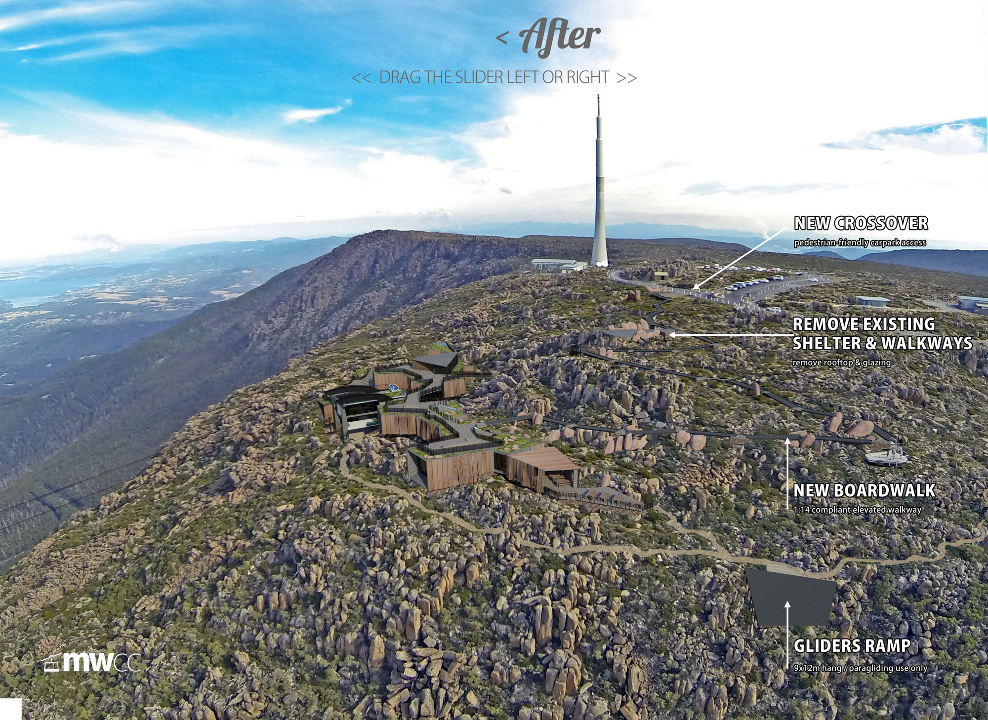
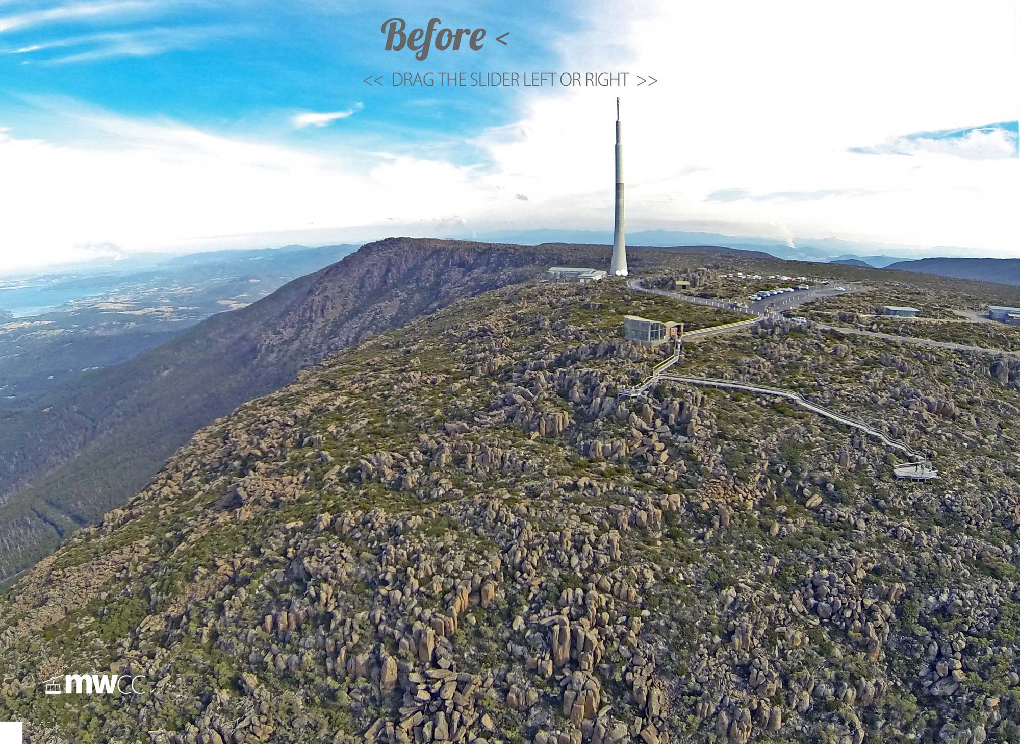
Whilst the bulk of visitors are likely to arrive by cableway, we propose to build an inclusive, non-slip elevated and ramped boardwalk, with lookouts and immersive points of interest between the Pinnacle Centre and existing carpark. This allows for the removal of the existing non-compliant timber walkways.
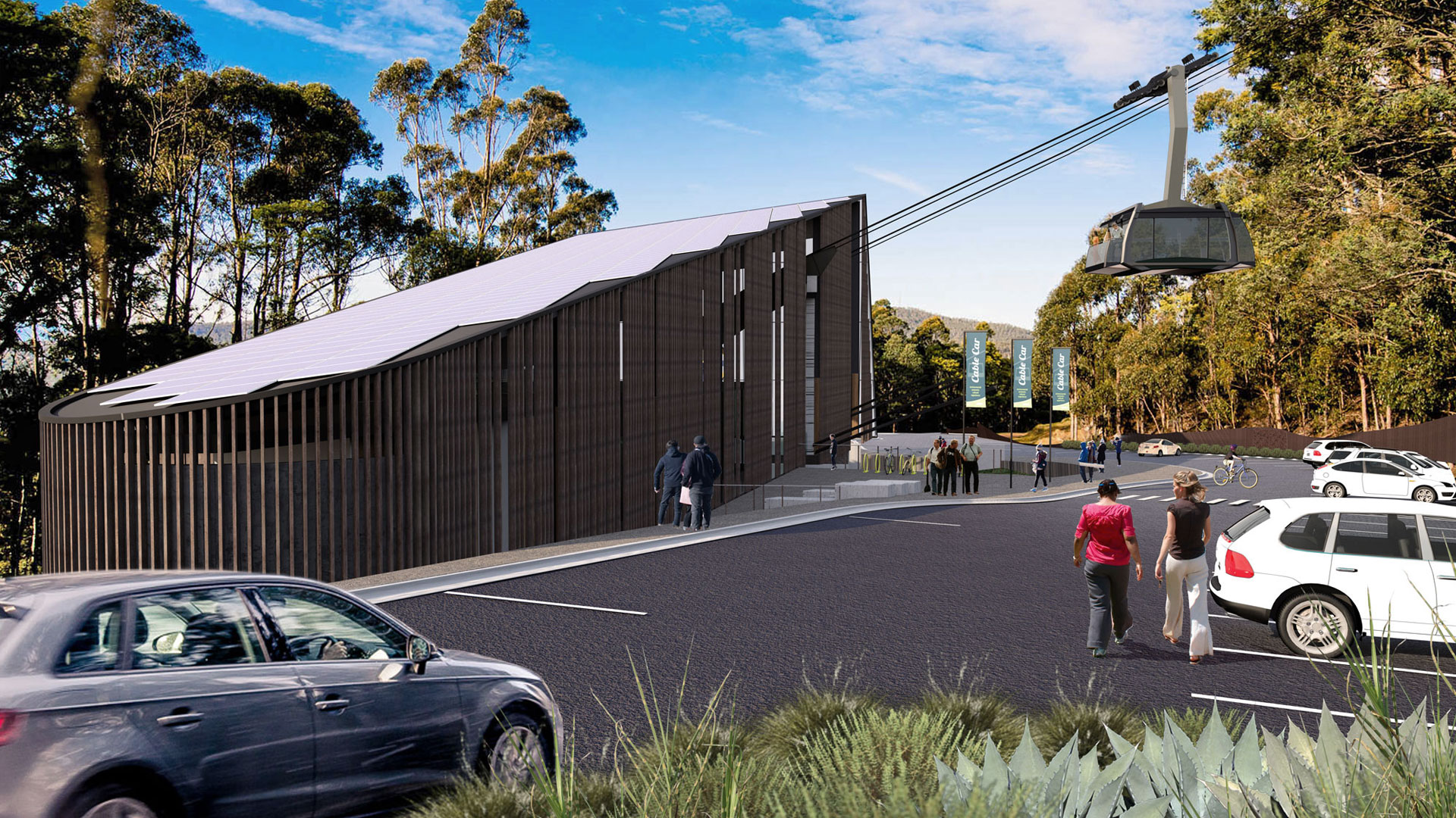
BASE STATION
Our Proposed Base Station nestles in a lush, tranquil yet previously deformed clearing on the Main Fire Trail on the fringe of Wellington Park, in a precinct that once was host to secret cabins and weekend retreats. This area was the primary walking route up the mountain long before the road. Our proposal recreates this gateway into Wellington Park with an ideal hub to integrate with new and existing walking and mountain bike trails.
OPERATIONAL HUB
Discreetly positioned to minimise vegetation clearing and maximise bushfire management, it will host the cableway motor room, backup generator, loading bay and service utilities, as well our front ticket office, mountain bike hire and staff amenities.
ACCESS
Our proposal seeks to install a new road from McRobies Road, installing underground services such as sewer, reticulated water, NBN and power for safer bushfire management.
MASTERPLAN
THEN AND NOW
Our Preliminary Proposal launched in 2014 stretched two cableway systems 4.6km from the Cascade Brewery. Whilst public feedback was overwhelmingly supportive, a year later a key section of bushland behind Cascade Brewery was rezoned which made it near impossible to continue with our intent to preserve vegetation and keep our system high above the forest canopy.
After the Cable Car Facilitation Act 2017 became law, (supported by over 5300 Tasmanian petitioners to Parliament) we resolved to investigate a shorter, simpler alternative that keeps the entire project contained within Wellington Park. Once the technical suitability was confirmed by our engineers in Switzerland, we consulted with as many nearby residents as possible (that such a change could mostly affect) before we made a final determination to pursue this more achievable plan in June 2018.
FINALISED ROUTE
Our proposed cableway length is 2.6km which retains a height gain of nearly 1000 metres. This finalised alignment allows us to honour all of our voluntarily adopted community parameters, with just one custom-designed straight-line system tailored made for kunanyi / Mount Wellington. We decided to reinvest cost-savings from our preliminary proposal into better and much-needed public amenities at the summit to ensure the experience is not only world class, but spectacularly memorable for all ages and abilities too.
APPEAL AMENDMENT
Our Appeal Amendment (lodged November 2021) proposes a scaled down version of the Pinnacle Centre, a reduction in operating hours to largely daylight only, and a reduction in capacity for our two Skytram cabins. Details Here.
Discover what's proposed below...
Public Facilities
Public Facilities
AMENITY FOR ALL
The following components of our Proposal have all carried through from your wish-list of ideas put to us in 2013.
COMPLIANT BOARDWALKS
Tasmania's third most popular visitor attraction has been neglected for too long. No longer is it acceptable than anyone with a wheelchair, walking frame, pram or stroller be denied access, yet that is what greets less-agile visitors wanting to experience the view. And for those able to, the primary outdoor lookout was closed to the public in November 2021, neglected for two years and quietly removed by Council in late 2023.
We propose to remove and rehabilitate all of the remaining timber & chicken-mesh walkways and replace these with fully-ramped and safer, non-slip boardwalk designed for the alpine environment. This new boardwalk will feature curious viewpoints and interpretation whilst meandering above the fragile flora and fauna to connect our Pinnacle Centre with the summit car park.

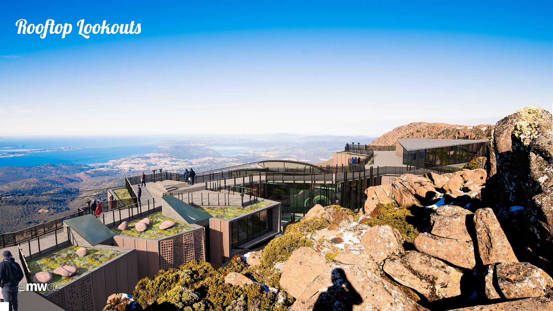
IMPROVED LOOKOUTS
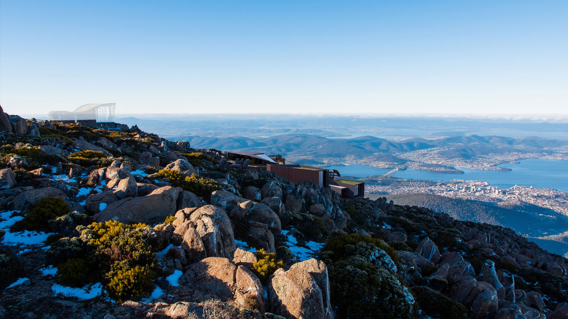
The rooftop of the proposed Pinnacle Centre will be the new public lookout, with ample space and opportunity for all ages and abilities to enjoy the view. The non-slip surface will be heated with a hydronic system to deter snow build-up, with multiple viewpoints and seating to invoke contemplation and soak up the vista.
Clever balustrading to mitigate snow-farming with a heated hand-rail, and opportunities for curious interpretation completes the public space, surrounded by native alpine gardens to the rooftop edge tended to by our onsite botanist.
24/7 ALWAYS OPEN SHELTER
The existing shelter is closed overnight from before dusk to well after dawn. Extended closing hours through winter means there is next to no refuge from the elements for much of the year when avid sunrise photographers, Aurora spectators and stargazers want to be up there.
Our proposal includes a new public shelter on the rooftop, providing year round a, whilst stairway and lift access inside the atrium to the building below is locked overnight.
COMMUNITY EVENT SPACE
A key request in our design brief, we are delighted to include a wind-sheltered, rooftop amphitheatre that celebrates the vista beyond. For general public use and community events, this space can be used for story-telling, music, wedding photos and school excursions, or just an ideal spot to pull out the thermos, set up the family picnic and admire the city views after a great day out on the mountain.

MORE TOILETS & PARENTING ROOMS
Despite the Council spending half a million dollars on 8 new public toilets at the summit in 2014, any quick glance at visitor feedback on TripAdvisor will quickly reveal how inadequate and smelly they can be.
Our Proposal includes 34 new toilets including 5 disabled facilities and a parenting room for young families. These are conveniently located throughout the Pinnacle Centre from the cableway platform to the cafe.

FIRST AID, CCTV, WIFI & SECURITY
On-site staff at the pinnacle brings a wealth of benefits for its visitors and the environment. From improved security and better waste management to reduce littering, our proposal also includes a full-time medical specialist at the summit for any unforeseen circumstances.
Free public WiFi will also be available throughout the visitor centre.

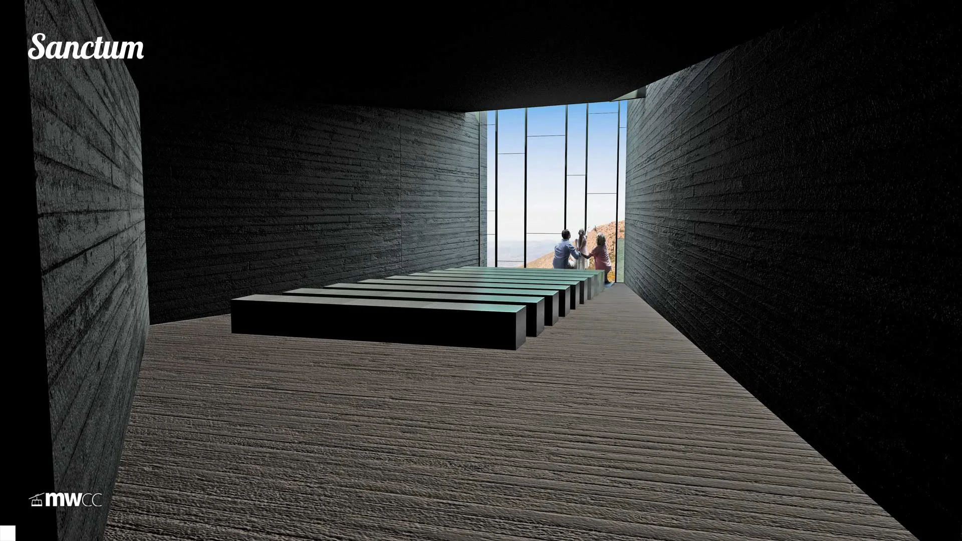
A SANCTUM
In addition to the outdoor amphitheatre, our Proposal offers something entirely new for the pinnacle. A public space of solitude, silence and contemplation.
Facing true south to beautifully frame the South Wellington range 'Iron Filings', this Sanctum to the Mountain is a refreshing, ceremonial atmosphere tucked away from the hustle and bustle of the cableway terminal, cafe and scenic-loving crowds.
STORY TELLING
Starting from the moment you walk in from the cableway platform, stories from the mountain's billion year old geological decay, the aboriginal values, colonial resource extraction and the modern day balance of recreation and conservation will abound.
MWCC will seek to collaborate with some of Tasmania's finest artists and story tellers to ensure this becomes a highlight - a curious, educational journey for any visit to the mountain.

40% of the Pinnacle Centre is free public amenity. Scroll down for more...
Recreation
Recreation
NEW & IMPROVED FACILITIES
We've committed to funding new recreational infrastructure once operational:

SAFER WALKING TRAILS, DEDICATED BIKE TRAILS
Shared use trails are not working. Both bushwalkers and bike riders share with us their constant frustration at the current situation; their outdoor experience is diminished by levels of anxiety and risk on shared trails.
In response, MWCC will fund the development of new and dedicated MTB downhill gravity-assisted trails that link together a workable and exciting network, freeing up walking trails - for bushwalkers. Trail development will be funded by our Community Fund once operational, starting with a new trail connecting the Pinnacle Centre platform to Pinnacle Road towards Big Bend. Additional trails, including an epic downhill trail connecting the Chalet to Junction Cabin are set to complete the missing links.
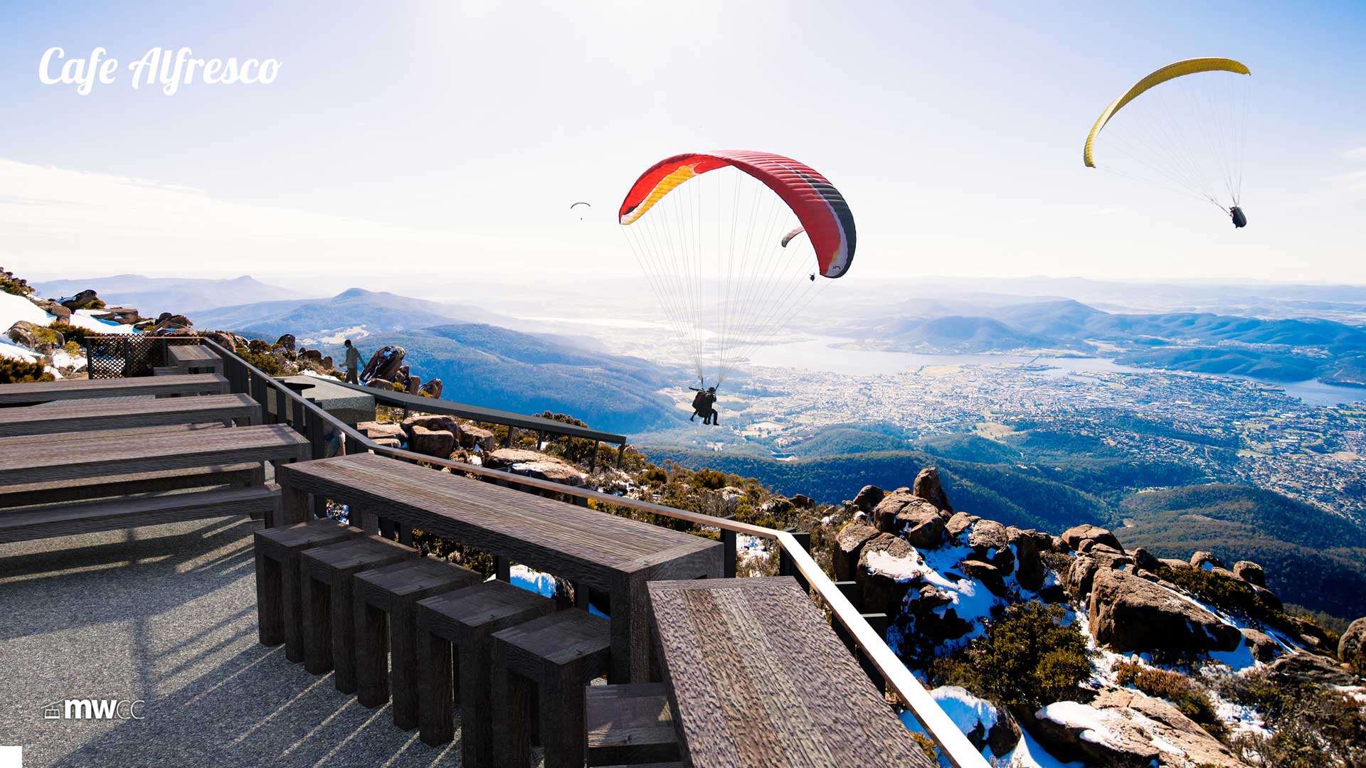
PARAGLIDING LAUNCH RAMP
To date, local hang-gliding and paragliding enthusiasts haven't had a formal or permanent place to launch, having to negotiate rocks, peg tarpaulins down over vegetation or clear specific areas of vegetation to improve safety and reduce risk. In addition, the logistics of attempting multiple back-to-back flights during favourable conditions has usually required the assistance of friends or family.
With a dedicated summit ramp and fast return via cableway, we're keen to make this mind-blowing pursuit safer and more environmentally friendly. It would be great to foster a flight school and tandem tour operator to setup shop too. Park. Fly. Repeat. Enjoy!


SNOW PLAY & SNOWBOARDERS
'Family fun in the snow' rated extremely highly in the 2200+ responses received through our Local Values and Opinions Survey conducted in 2013. Since then, we've met with local snowboarding groups and enthusiasts to ascertain what facilities, infrastructure or assistance we could provide to encourage stronger active use of the Mountain's winter months.
In response, we're providing:
Sport Lockers for hire in our Pinnacle Centre,
Storage for removable Terrain Park equipment, and
Snow trolleys, to continue the tradition of car-bonnet snowmen.
ROCK CLIMBING
Whilst no new dedicated facilities are proposed for rock-climbers, our Proposal is designed to ensure this adventurous community can continue to access and enjoy enthralling locations on the mountain. From experience abroad, it is expected that rapid access to/from the summit will aid this pursuit and provide emergency rescue services dedicated access to the base or top of the Organ Pipes, should the need arise.
Notably, MWCC pledges to adopt the same protocol as Cape Town's Table Mountain Aerial Cableway Co. whereby our cables will not be externally greased. Whilst this increases the maintenance cycle for our cableway it is a sensible move and one that is welcomed in Cape Town by the local and international rock climbing community.

Looking for a drink or bite to eat after all that fresh air?
Scroll down to put your feet up and soak in our hospitality...
Food & Beverage
Food & Beverage
COSY CORNERS TO CELEBRATE
What better way to let visitors spend more time appreciating the mountain than to sit down over an offering of the best Tasmanian produce?

indicative only
ALL DAY CAFE
Hot Chocolates. Barista coffee. Wood-fired pizza - Just some of the hearty menu items you'll find in our cosy, modern alpine cafe in the Pinnacle Centre.
Featuring spectacular views with nooks for families, groups or lone travellers, the cafe will operate year-round. A communal walk-around fireplace is set to become a focal point when the summit is snowed-in, whilst patrons can soak up the summer rays on a wind-sheltered alfresco deck and watch paragliders launch from their ramp nearby.
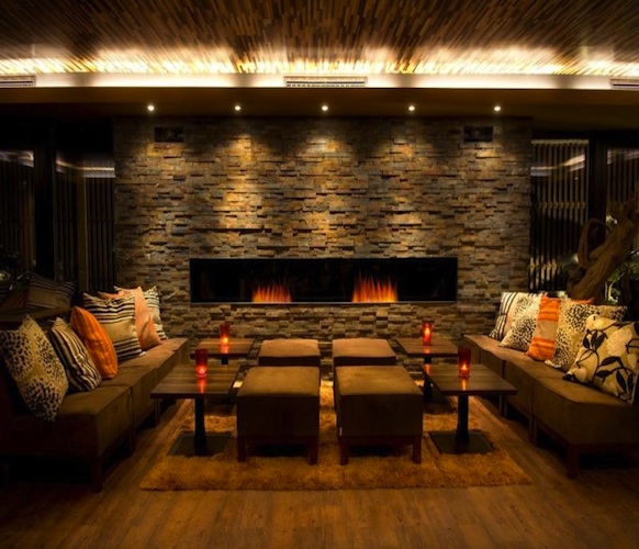
CRAFT BAR & ARTISAN LOUNGE
Showcasing the finest selection of Tasmanian wine, whiskey, gin, beer and cider, our proposed Craft Bar will be a connoisseirs delight.
A tantalising alpine bar featuring Tasmanian timbers with unforgettable views to the Iron Pot and South Wellington range. A roaring open fire, knowledgeable Sommeliers, locally-made designer furniture and a grand piano. All the ingredients to celebrate that special occasion, a tempting pre-dinner drink, watching the snowflakes float by or a nightcap to linger a little longer until the last Skytram descends for the night.
indicative only

FINE-DINING RESTAURANT
(removed under appeal amendment)Extending from the Craft Bar, we propose a fine-dining restaurant to rival the most renowned in Australia with arguably the most spectacular view.
The restaurant, its event planner, chefs and staff can be booked for private functions such as weddings, community, sporting or corporate events with a seating capacity of 140 (round tables of 10), expanding up to 200 if the Craft Bar & Lounge is hired as well.
A magical place to pop the question!
So, how does this fit all together?
Scroll down to view the floorplans, elevations and impressions below:
Architecture
Architecture
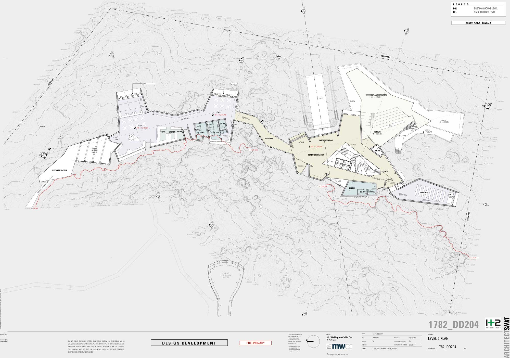
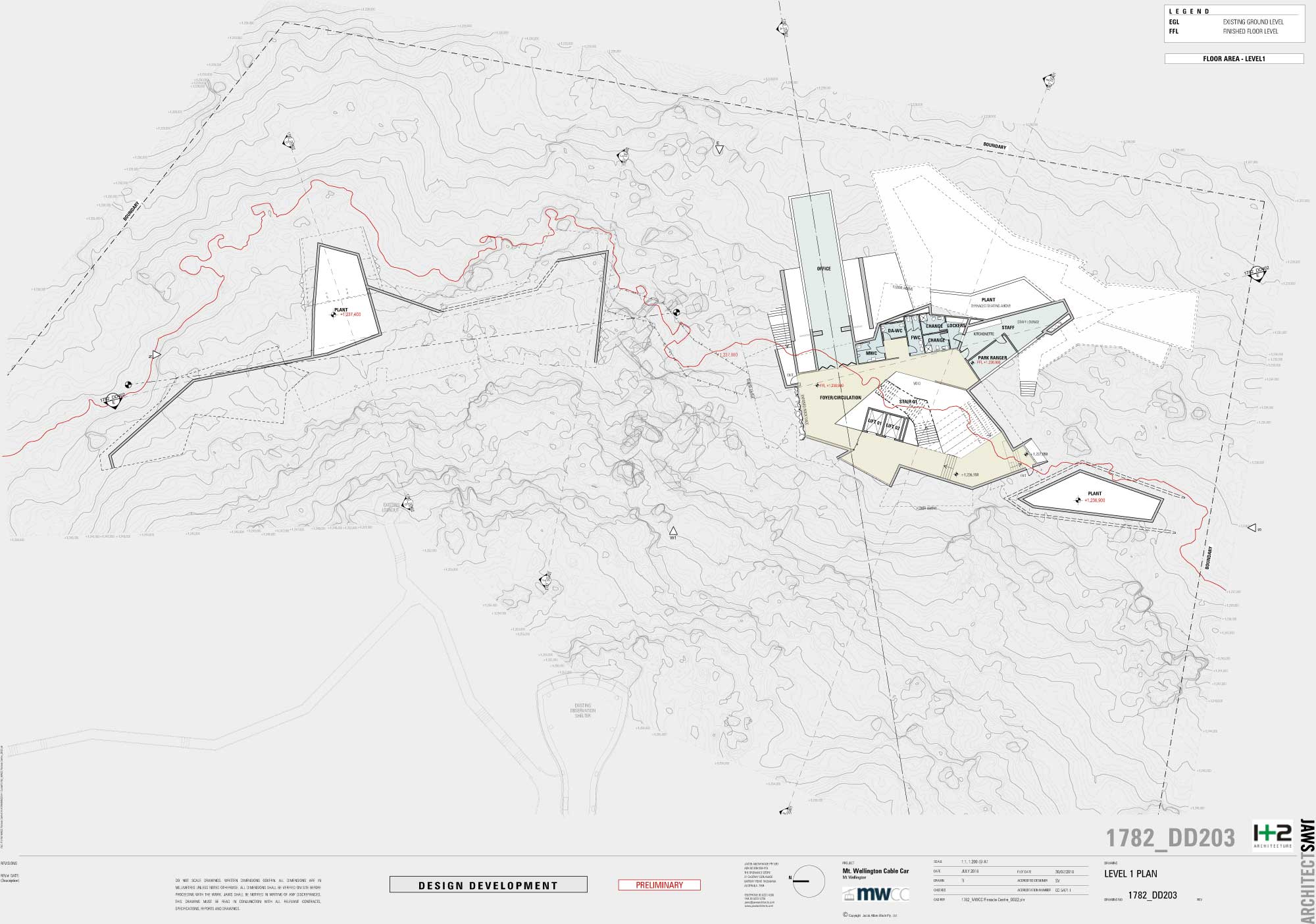
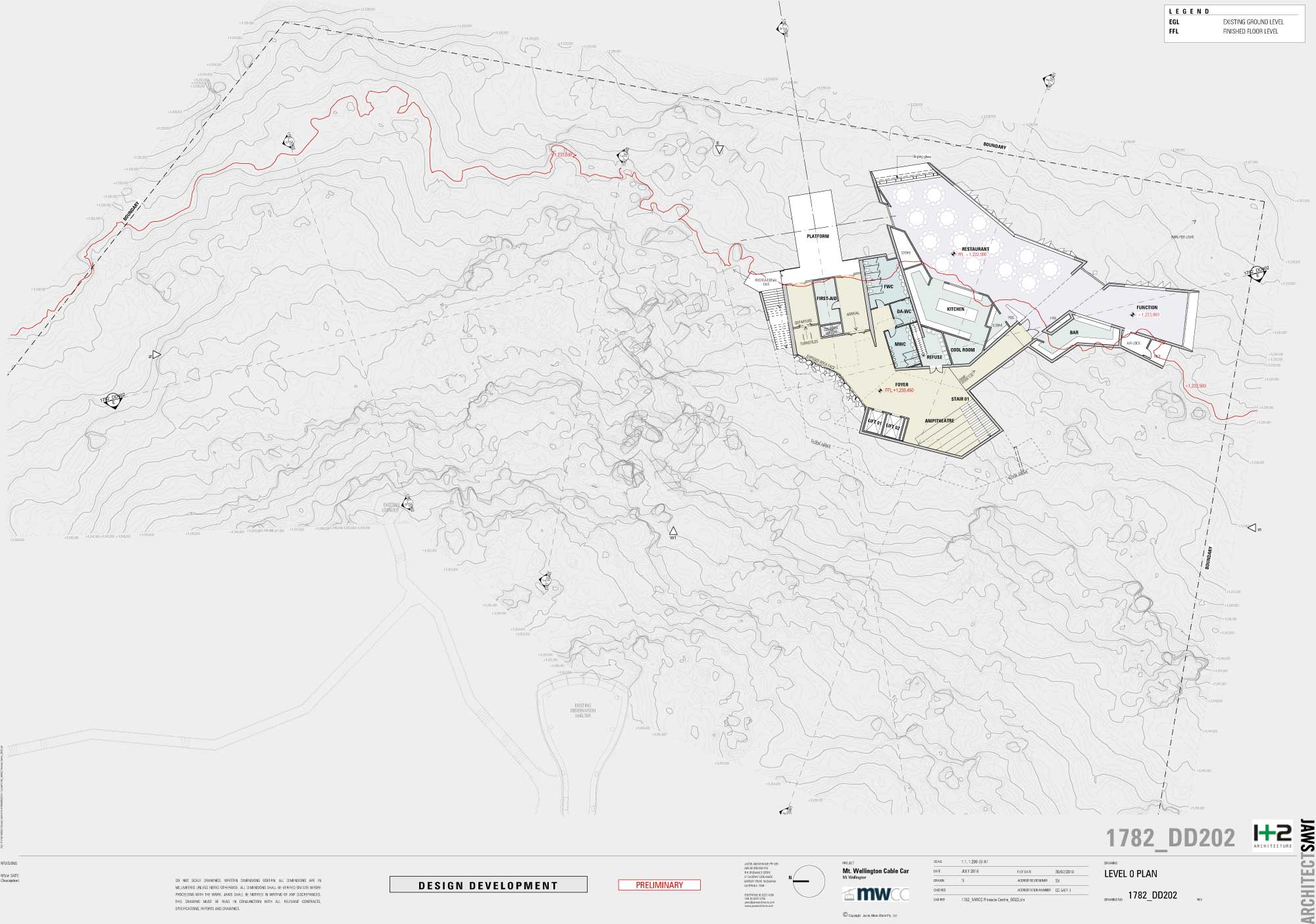
PINNACLE CENTRE FLOORPLANS
(Lodged DA version below. Updated plans for Appeal Amendment available here)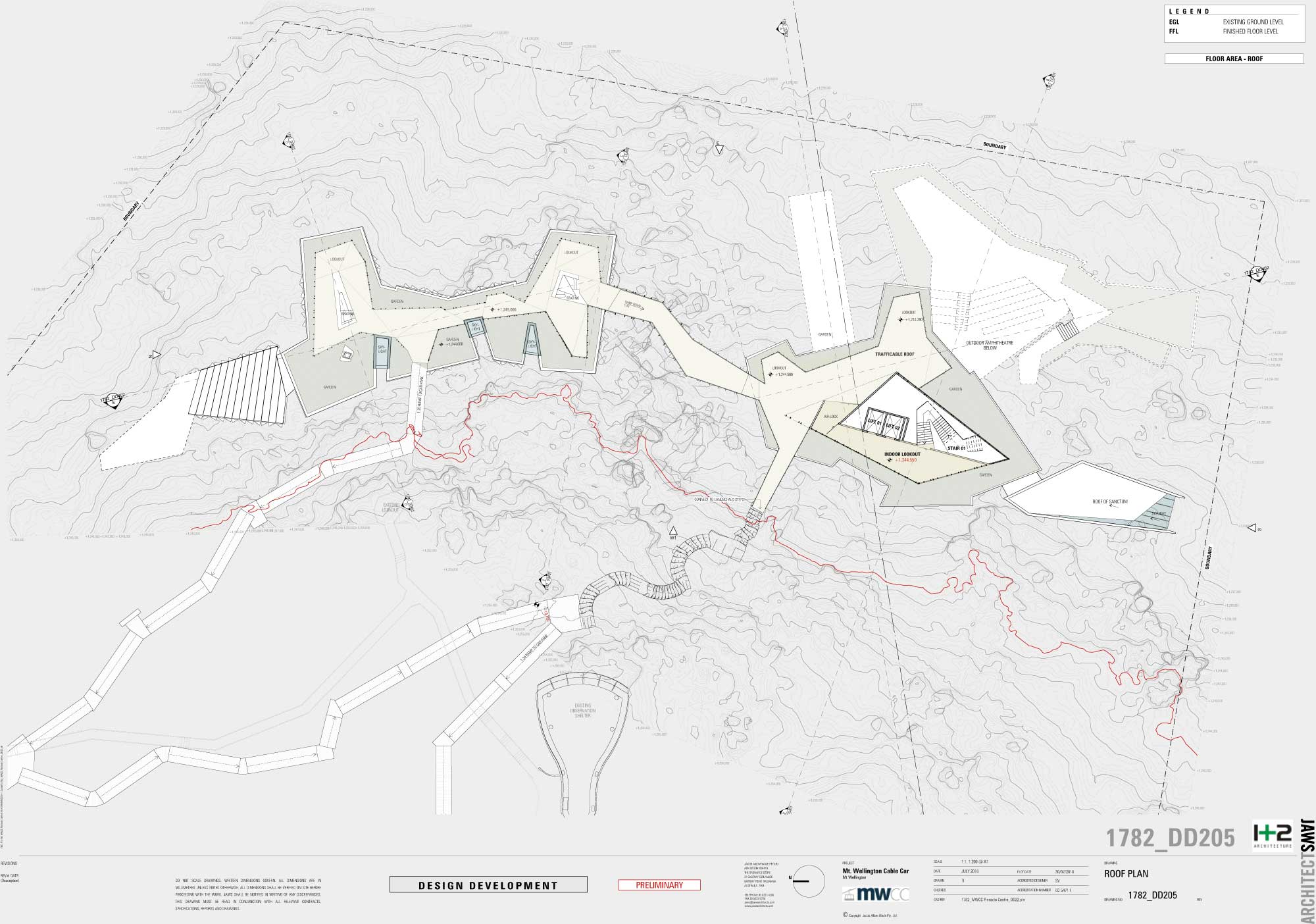
ELEVATIONS
NORTH ELEVATION
Optimising the natural tiers of the site has allowed the northern profile to sit discreetly within the landscape, which can be enhanced by the removal of the existing shelter. Be sure to check the Visual Impact Analysis to see the building in 3D from around Hobart.
CLICK TO ENLARGE
SOUTH ELEVATION
The bulk of the southern profile sits discreetly within the landscape and below the horizon, which can be enhanced by the removal of the existing shelter. Be sure to check the Visual Impact Analysis to see the building in 3D from around Hobart.
CLICK TO ENLARGE
EAST ELEVATION
The key challenge set in our Design Brief was to deliver a solution that sits below the silhouette of the mountain when viewed from Sullivans Cove. This fantastic result would not have been possible if we had not successfully lobbied for an extension to the planning scheme in 2014/2015. Be sure to check the Visual Impact Analysis to see the building in 3D from around Hobart.
CLICK TO ENLARGE
WEST ELEVATION (into the mountain)
This profile is unlikely to seen in its entirety due to much of it built close up against the mountain's dolerite rock.
CLICK TO ENLARGE
PLEASE NOTE: ELEVATIONS ARE 2-DIMENSIONAL. KEEP SCROLLING TO SEE TRUE VISUALISATIONS FROM AROUND HOBART.

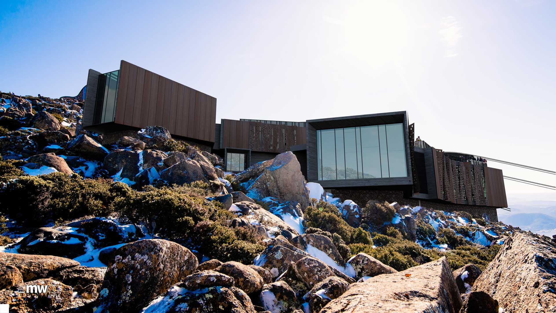
EXTERNAL AETHESTICS
Constructability and Materiality have been just as important for the team to consider as has been planning the functional layout, circulation, compliance, acoustics, lighting, heating and atmosphere of the proposed Pinnacle Centre.
Shown here is a cross-section detailing the use of natural local stone from the site for the building's pedestal base, as well as the tailor-made, weathered steel facade proposed for the bulk of the concrete and fire-proof shell.
EMERGENCY REFUGE
In case of sudden, unexpected and catastrophic fire danger, the building is designed to act as a safe refuge for all mountain visitors - a marked improvement on the status quo.
All designs are Subject to Council Approval (STCA). View the full architectural blueprints on our download page.
ANIMATION
ARTIST IMPRESSIONS
SHARE THE BLUEPRINTS WITH FRIENDS AND FAMILY:
What will this look like from around Hobart?
Scroll down to explore the Visual Impact:
Visual Impact
Visual Impact
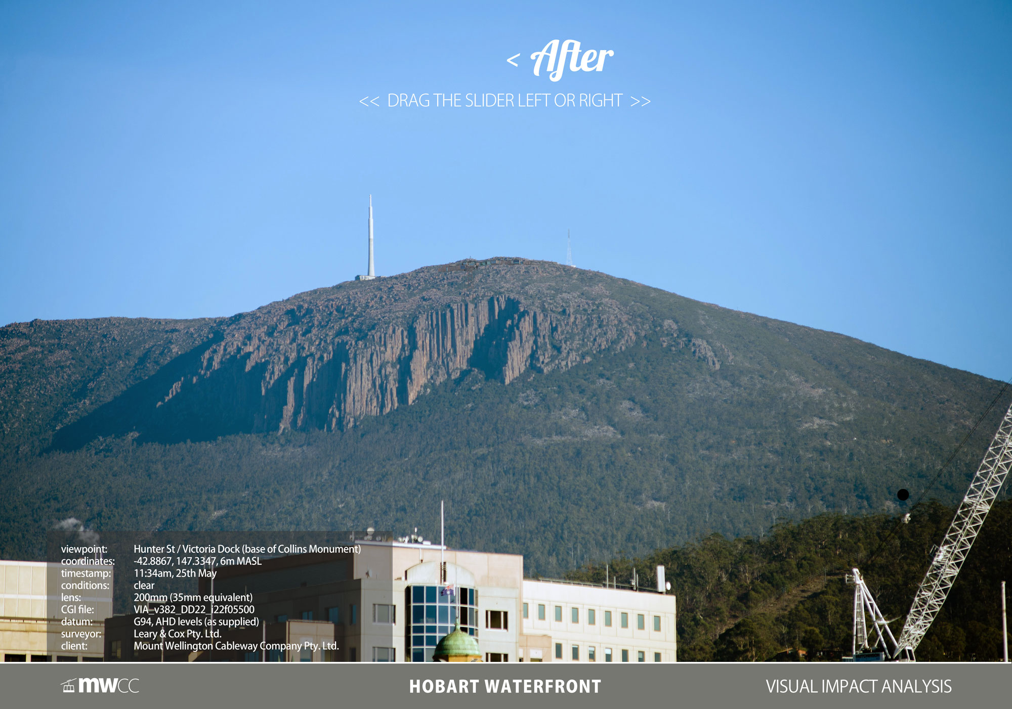
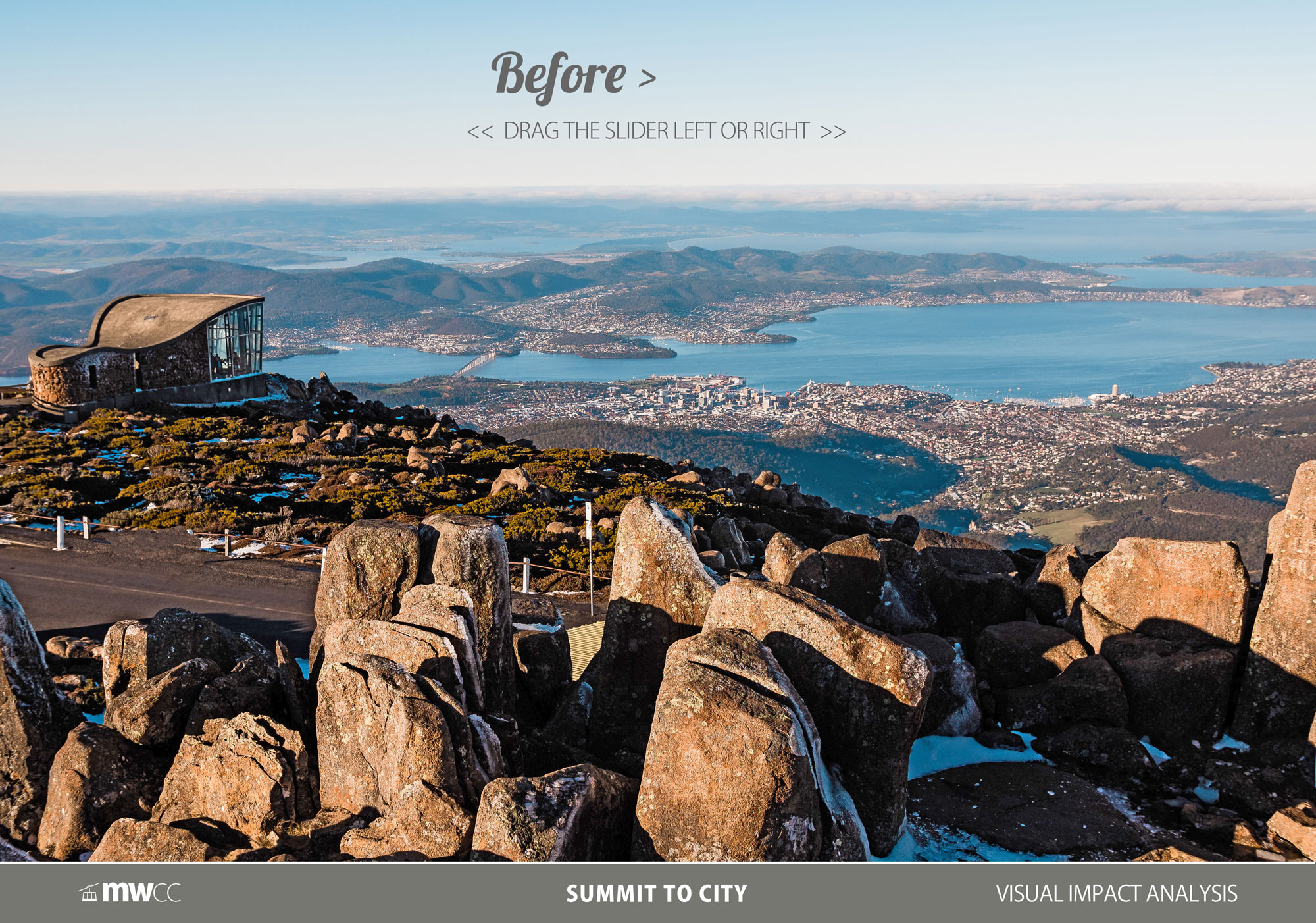
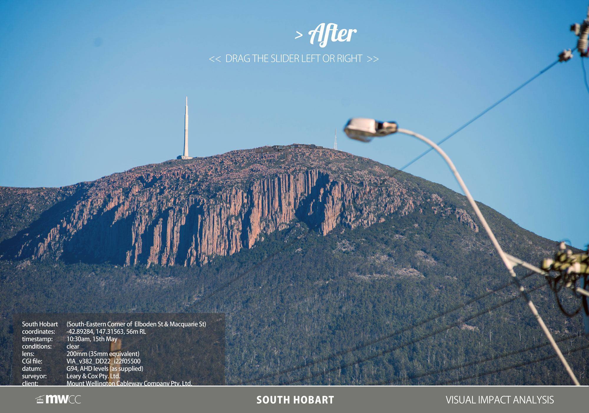
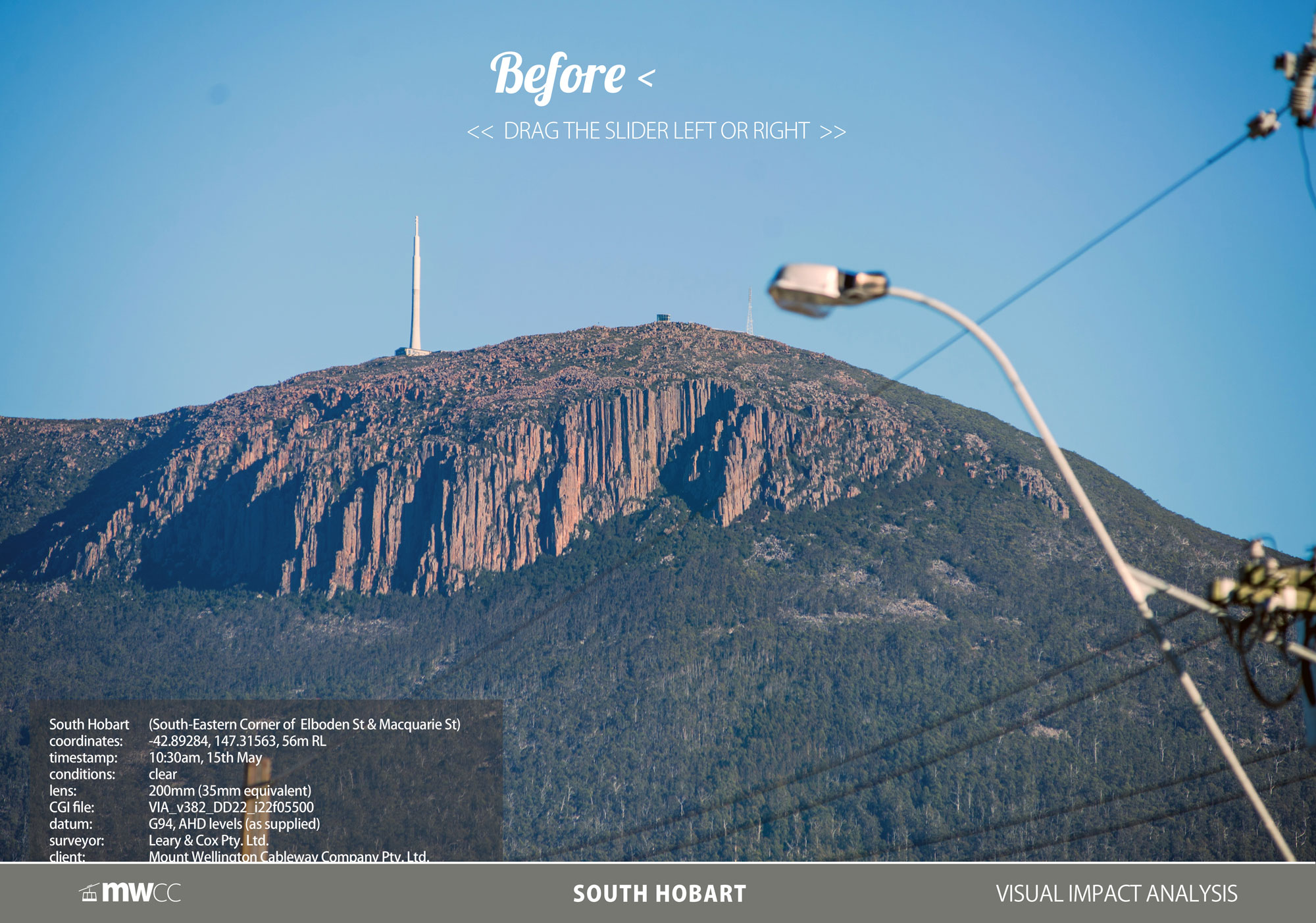
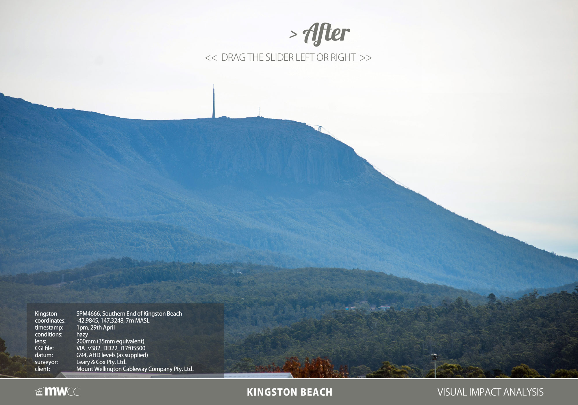
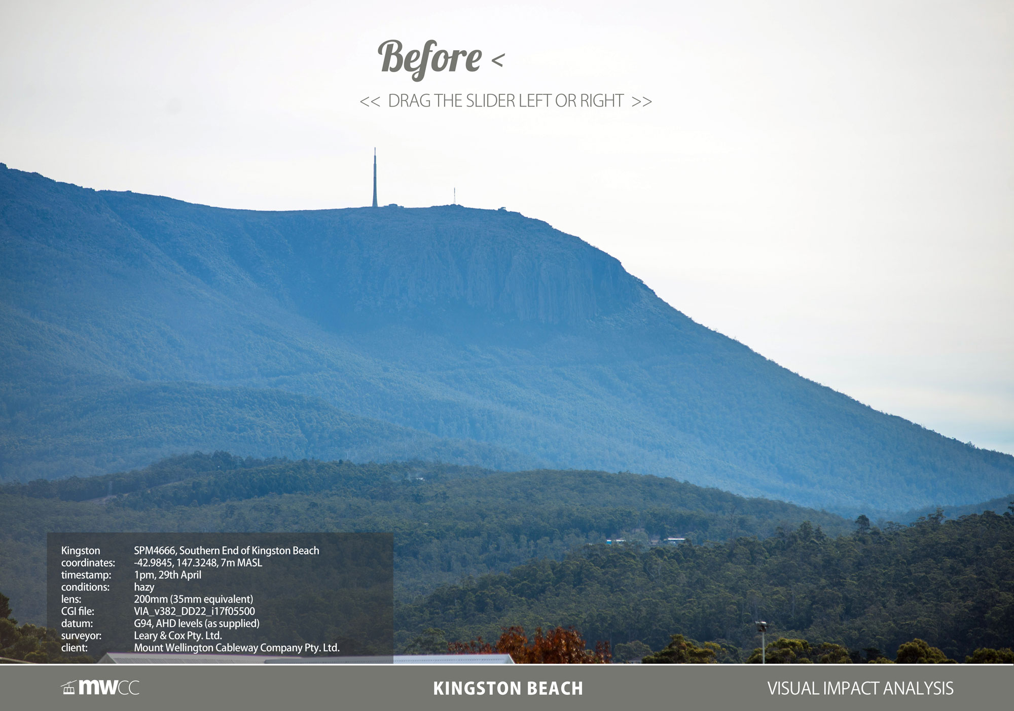
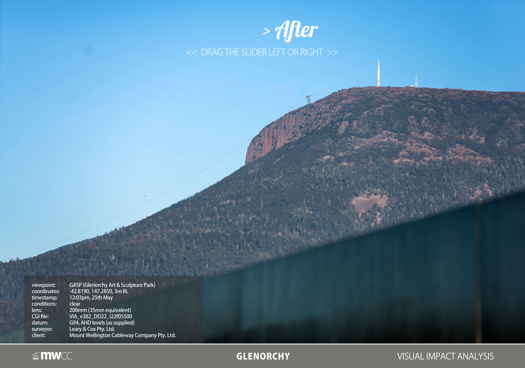
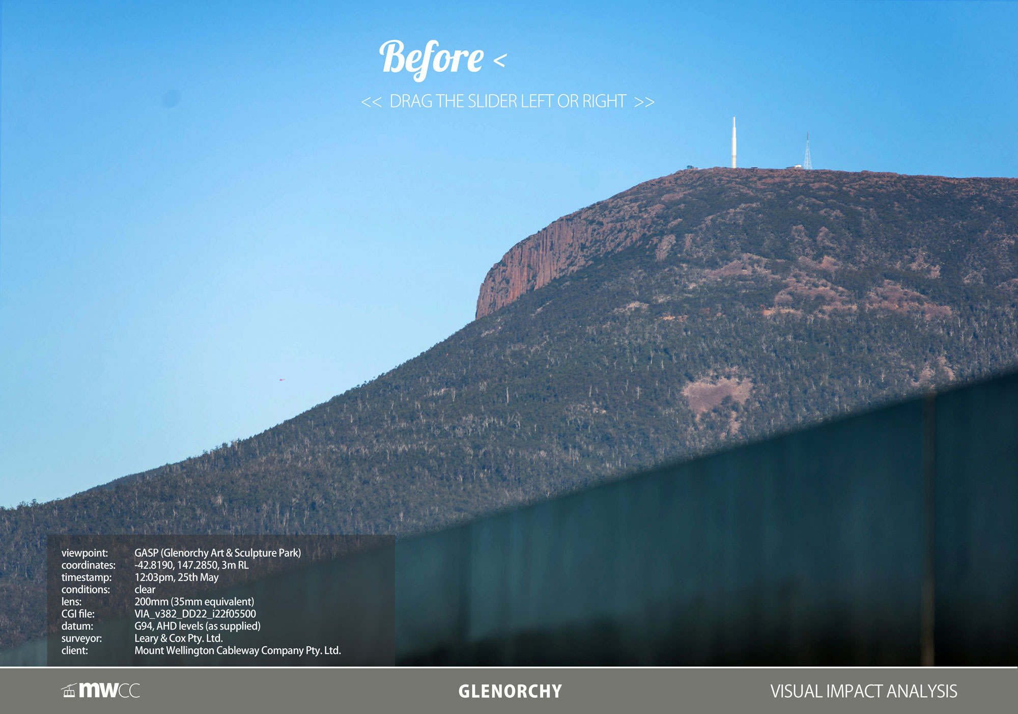
RESPECTING THE SKYLINE
(Lodged DA version shown)We are delighted to have pushed the world's best and most experienced tramway engineers to achieve a single summit tower solution; - a solution only achievable with our proposed route.
INSTRUCTIONS: Simply click and drag the white slider on each image left and right to discover the difference.
FROM THE CITY:

FROM THE SUMMIT:

FROM SOUTH HOBART:
FROM KINGSTON:
FROM GLENORCHY:
FROM SALAMANCA:
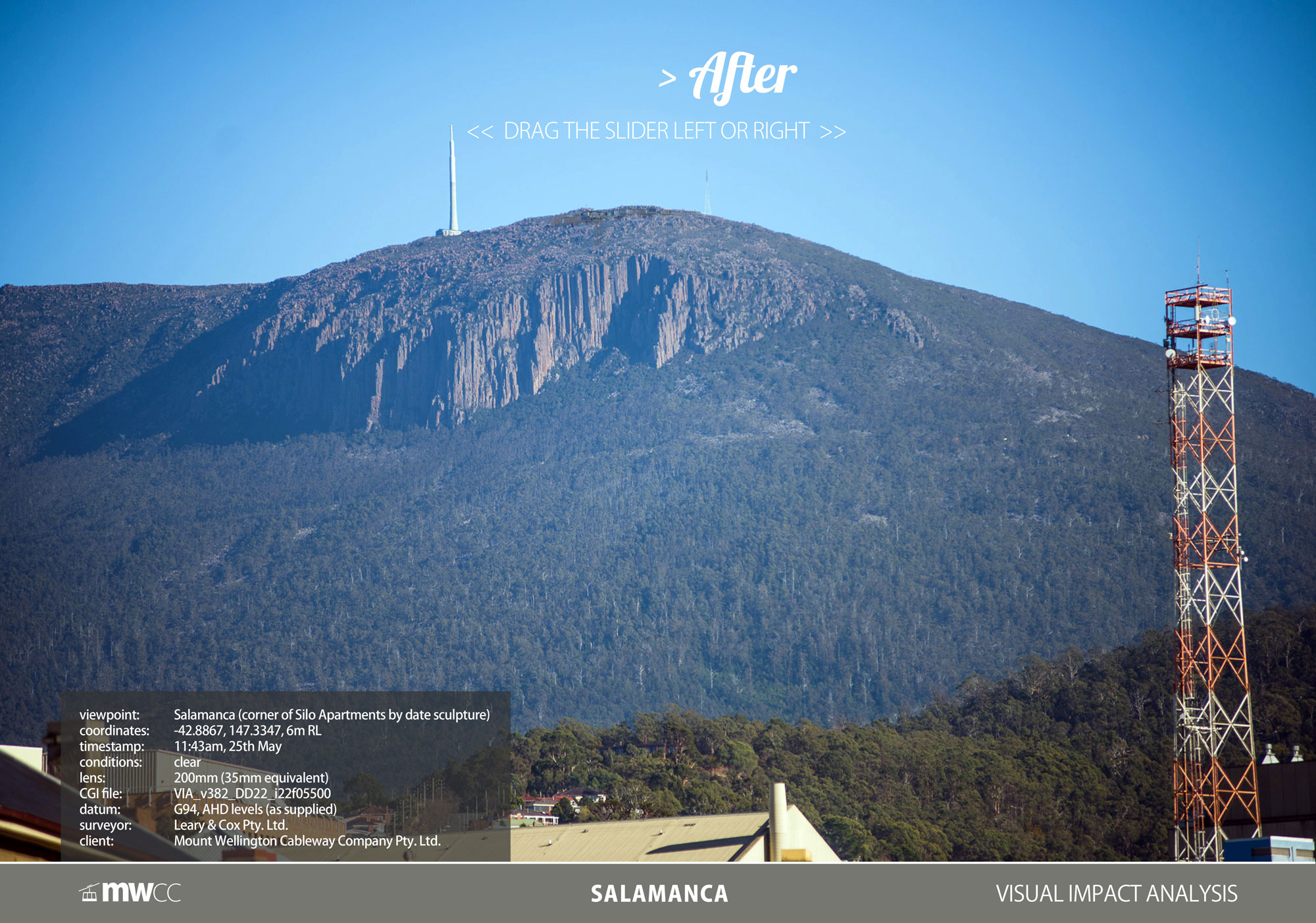
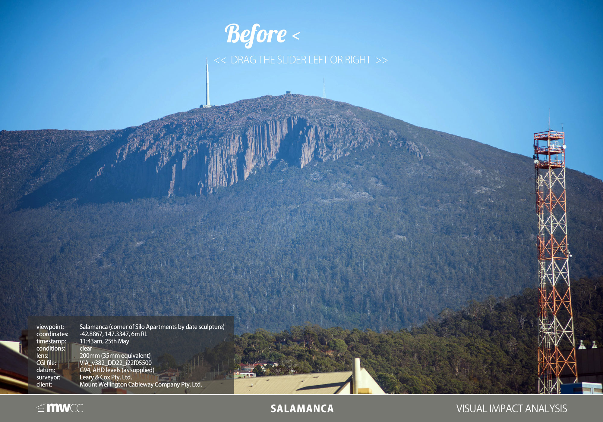
* All designs are Subject to Council Approval (STCA). The full Visual Impact Assessment is available on our Downloads page.
SHARE THE VISUAL IMPACT WITH FRIENDS AND FAMILY:
So that's how it should look from around Hobart. Is the impact better than expected or worse? Scroll down one last time for the traffic impact on and off the mountain.
Traffic Impact
Traffic Impact
SMARTER TRANSPORT
A shorter, safer route through a mixed zone precinct.

HUON ROAD,
PILLINGER DRIVE &
PINNACLE ROAD:
181,383 LESS VEHICLE TRIPS PER ANNUM
With a significant reduction in road traffic up the mountain (59.6% high scenario, 42.4% low), not only can our native wildlife catch a break, we believe the lifespan of the 80 year old road can be extended. This avoids the costly and unsightly widening that would otherwise need to occur without our sustainable transport solution, (It has taken 50 years of regrowth to hide the road scar) and less pressure on emergency services.
Less traffic also means up to 700 tonnes* less carbon emissions in the Park, whilst offering a safer road and quieter experience for families of all ages, bird-watchers, bushwalkers and bikers.
With more visitors from less vehicles, the likely forecasted impacts are shown below:

CASCADE ROAD
5.63% EXTRA VEHICLE TRIPS PER ANNUM
Cascade Road is the artery of South Hobart, currently serving nearly 3.1 million vehicle trips each year and carries only half of its built capacity at peak times.
Weekends on Cascade Road are significantly quieter and this is when we expect to be our busiest. We also propose to operate slightly different hours between Summer and Winter, providing four operating models throughout the year.
On weekdays, we propose to only open after the morning rush hour of 8 - 9am.
We also propose to incentive customers to use our regular shuttle service from the waterfront, reducing the number of cars further. In total, we expect an annualised average of 1 extra vehicle trip (either way) every 79 seconds during open hours.
A copy of the full Traffic Impact Assessment is available on our Downloads page.
NEW LINK ROAD
Included in the Proposal is a new link road from the roundabout at the end of McRobies Road (before the tip gate) to our proposed Base Terminal. This link road will be an S4 class sealed rural road and provides a legitimate connection from the Tip-Top mountain bike trail onto McRobies Road - a current missing link.
It joins the Main Fire Trail by the high-voltage transmission lines at the boundary of Wellington Park, providing safer and faster emergency access into the foothills of Wellington Park.
This road alignment has been carefully refined since August 2018 after our team conducted extensive ecology studies in the area. Roadkill mitigation designs are expected to be employed.
BENEFIT FOR SOUTH HOBART RESIDENTS
MWCC has listened to local residents about their existing traffic issues on Cascade Road. In response, MWCC propose a tiered road with a new T-junction: The existing one-way slip lane turn-off to McRobies Road is upgraded to cater for two-way traffic. West-bound traffic remains unchanged (upper tier) whilst vehicles wanting to turn into McRobies Road can seamlessly drive down the new two-way road and give-way at a new T-Junction on the lower tier. City-bound traffic flows down and through the lower tier but with the added benefit of being able to turn into McRobies Road at the T-junction.
Whilst this optional upgrade is not required for our project to comply with the planning scheme, MWCC commissioned civil engineers to confirm whether this recommendation is practical and technically achievable solution within the existing road easement. If upgraded, this new junction will divert all current tip traffic away from the Female Factory Historic Site as well as residential properties in Degraves and narrow Apsley Streets.
It also provides new traffic-calming measures for the Rivulet Track and additional off-street parking for residents.
SHARE THE TRAFFIC IMPACT WITH FRIENDS & FAMILY:
Net Reduction in HOBART'S carbon footprint
* Carbon emissions were calculated based on 12 month traffic data collected 2009-2011 on Pinnacle Road and FCAI emissions data assuming every vehicle (motorbikes up to minivans) is a standard 2013 model unleaded small car. This was measured on the difference in distance from the common juncture of Southern Outlet/Davey St intersection to both Cascades versus the Pinnacle. This provided a total result in excess of 1100 tonnes per annum on 2011 traffic visitation data. Significant increases in traffic since 2011 and slightly more efficient vehicle data from FCAI are yet to be modelled.

So there you have it. Love it? Still have Questions?
Please scroll down (one last time) to see the summary of community feedback received.
Application Lodged
Application Lodged
PUBLIC FEEDBACK RESULTS:
Thank you!
Over 8,000 Tasmanians responded during August and September 2018 to our call for feedback on the above designs. Feedback was received over two months at our Public Display Centre at Brooke St Pier and via this website. From all of us at MWCC, we are so grateful for your time, honesty and considered thoughts. Your input helped us improve the final detail which was formally lodged for council approval on the 12th June 2019.
The council sought public feedback over a 4 week extended statutory submission window to June 22, 2021. You can participate here.
SHARE THE OFFICIAL DETAIL WITH FRIENDS AND FAMILY >>